Eastern Mediterranean Basin Synthesis (EMBS)
Tectonostratigraphic Controls and Geochemical Indicators
Eiichi Setoyama, Ph.D. | Rasoul Sorkhabi, Ph.D.
Status: In Development | For Sponsorship | Report Number I 01407
Cost for sponsors:
The study report is delivered on the ArcGIS platform.
Duration: 12 months
An integrative digital database for the Eastern Mediterranean distilling a huge amount of information and publications that are currently scattered. The database would also evaluate and standardize the information on the region borderded by eight different countries in the region, from Egypt and Lebanon to Cyprus and Turkey.
An easy-to-use geologic knowledge-base with a focus on basin evolution, structural framework, paleofacies distribution, geochemical evaluation, and origin of oil and gas accumulations.
Play fairway mapping of hydrocarbon prospectivity in selected key areas based on regional synthesis of information from wells, seismic, biostratigraphic, and geochemical data.
Better understanding of the geodynamic tectono-sedimentary evolution of the Eastern Mediterranean basins for oil and gas exploration with a focus on how tectonic and stratigraphic forces have controlled the key petroleum system elements from source rocks to traps.
An ArcGIS assessment and easy-to-use tool for analysis of the regional geology and petroleum plays in the region based on an integrative database that can be augmented with internal databases of the sponsoring companies.
SUMMARY
Situated at the intersections of Africa, Asia, and Europe, the Mediterranean Sea with a surface area of 2.5 million sq. km includes 12 local seas and gulfs as well as over 3300 islands. The Mediterranean is also connected through narrow straits to the Atlantic on the west, the Black Sea to the north, and the Red Sea to the south. Moreover, 22 countries in Europe, North Africa, and West Asia face the Mediterranean. This geographic setting has given the Mediterranean a geostrategic position in the world both politically and economically. Indeed, the very term “Mediterranean” (Latin, “interior of Earth’s landscape”) signifies its key position historically.
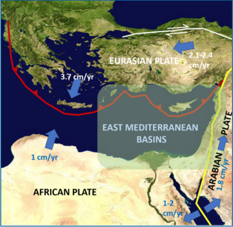
In the past two decades, the Eastern Mediterranean has witnessed the discovery of several major gas fields such as Aphrodite, Leviathan, Tenin, Tamar, Karish, Dalit, and Zohr in the Levant Basin. These, in addition to the classic oil and gas fields of the Nile Delta and Western Desert basins in Egypt, indicate the existence of a prolific petroleum province for exploration with proximity to major markets in Europe. Nevertheless, many aspects of the petroleum systems in the Eastern Mediterranean are little known, such as the distribution of source rocks and reservoir in space and time, the causes of microbial (biogenic) vs. thermogenic gas fields, the impact of the Messenian Salt Giants on petroleum systems, and the nature of deep plays. Some of these problems can be investigated through integration of geologic, geophysical, and geochemical data from both onshore and offshore areas. In this way, petroleum systems can be viewed against the background of tectono-sedimentary evolution of the Eastern Mediterranean basins.

Figure 1. Plate tectonic setting of the Eastern Mediterranean Sea
CONTACT TO PURCHASE
Rasoul Sorkhabi, Ph.D.| rsorkhabi@egi.utah.edu
Eiichi Setoyama, Ph.D. | esetoyama@egi.utah.edu
Phone: 801-581-5126
egi.utah.edu
